As satellite images reshape conflict, security worries mount
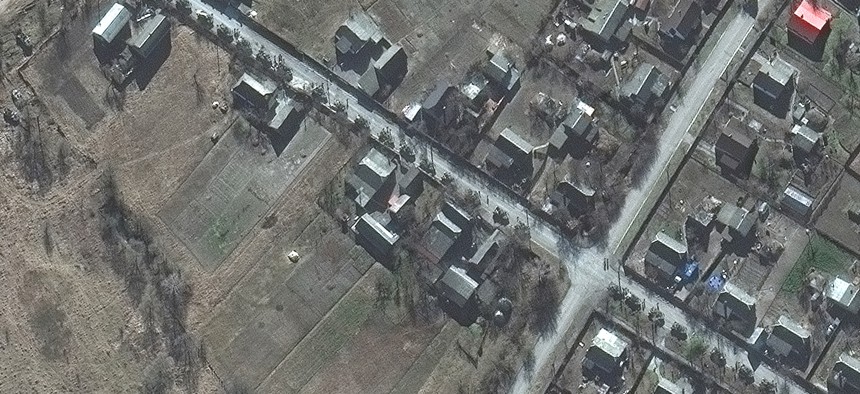
Satellite imagery from February 18th shows a Russian military convoy 17 miles from Kyiv, Ukraine Maxar Technologies


Radio data collected from space is the next frontier.
DENVER – If Russia is defeated in its war against Ukraine, it will be thanks in no small part to publicly available satellite images. Pictures of Russian military movements and actions have helped mount defenses, expose Russian falsehoods and war crimes, and galvanize Ukrainian allies. But precisely because the recent explosion in space-generated intelligence is proving so valuable, industry and military officials are concerned about potential adversaries’ growing abilities to target satellites.
In the leadup to the invasion, images bolstered leaders’ credibility as they issued increasingly dire warnings. After it happened, the photos helped policy makers in Washington, Brussels, and elsewhere marshal support for sanctions on Russia.
“You're in the middle of a war where a new piece of technology changes the calculus of decision,” Planet co-founder and CSO Robbie Schingler told Defense One. “It wasn't just ‘Trust us, this is happening.’ Everyone could see it. You're on a common operating picture” that enabled leaders around the world to “come up with their own decision making processes internally in their countries and then be able to act in unison when it matters.”
The images even helped force many large corporations to act.
“The thing I think that was really quite unique out of this is that companies—unilaterally, without laws—are choosing to pull out of doing business in Russia,” Schingler said “That was like an unintended consequence.”
Unlike military satellites that produce largely classified imagery, private-sector providers have much more freedom to release anything they like.
“The shareability of commercial imagery has always been one of the key features,” Tony Frazier, Maxar’s executive vice president and general manager of public sector earth intelligence, said at the GEOINT conference here this week.
The availability of satellite imagery they could share and talk about made it easier for the Biden administration to rapidly declassify their analysis of Russia’s intentions and actions, said Robert Moultrie, the defense undersecretary for intelligence. “That decision was made by the commander in chief: a gutsy decision to say we're going to disclose some of the most sensitive sense intelligence that we have… It has worked. I think it has helped turn the tide.”
The U.S. intelligence community is entering a new era in which publicly available intelligence is given more weight and in which the U.S. government is more transparent about what it sees, particularly about Russia and China. Moultrie called the U.S. effort to warn the public about the impending invasion “a case study for us. And it really is one that's going to really pave the way for the future.”
Some military leaders want to move even faster. Gen. Richard Clark, who leads U.S. Special Operations Command, said too much information remains classified, in part because it’s too easy for the national-security community to reflexively mark it as secret.
“I think we will learn from things like the current conflict in Ukraine that we have to be more effective. We have to open things earlier and yet every situation is going to be different. There are things that, as a nation, as a government, we have to protect and we should protect,” Clark said. “But I think we really have to put more emphasis on that declassification or…opening up to knowledge.”
But declassification and the wide availability of satellite imagery also present a new challenge: how do you gain an edge if everyone has the same picture? That’s where officials hope that artificial intelligence and new forms of space-collected intelligence, such as radio-frequency data, will create new advantages.
Frazier highlighted work that Maxar has been doing with the Army’s 82nd Airborne, as part of their Scarlet Dragon events, which occur every 90 to 100 days. Over the past 18 months, he said, they learned how to move images to troops on the battlefield in one-tenth of the time.
The company is also putting up more satellites, which “is going to allow us to continue to collect imagery at very high resolution, so 30 to 50-centimeter resolution, but then also be able to dramatically increase revisit over areas of the world that matter.” Over the mid-latitudes, the region between the tropics and the polar circles that includes much of Asia, “We'll have the ability to collect up to 15 times a day and then also be able to interweave that with other sources to just get persistence.”
In the years ahead, expect an explosion in other kinds of satellite-gathered data—for example, unencrypted radio chatter from military units that are broadcasting their location via global positioning. At the conference, Annie Glassie, a mission analyst with HawkEye 360, a satellite company that specializes in gathering radio signals, showed how her firm could identify ships that had turned off their AIS receiver— in effect, trying to go dark.
Kari A. Bingen, HawkEye 360’s chief strategy officer, said, “What we are able to detect is effectively.. those electronic warfare, those indicators, emitters, jamming GPS radars, other things that are a leading indicator of, frankly, where Russia forces are and where they're moving.”
Artificial intelligence is also adding value by combining satellite imagery with new forms of data, including in U.S. European Command’s activities near the Ukrainian border, said one senior executive with a satellite imagery company.
“The feedback we've received is that the capabilities both for the role of commercial imagery, the ability to apply AI machine learning against that data, and the things you can do with 3-D are playing a big role in supporting current missions,” he said. He declined to be named out of sensitivity to current operations.
But some officials and representatives from industry are increasingly worried that commercial intelligence satellites will soon become key targets for adversaries who want to return to the days when the world couldn’t easily track their military formations.
“Both Chinese and Russian military doctrine now capture their view of space as critical to modern warfare. And they consider the use of space and counter space capabilities as a means of reducing U.S. military effectiveness and for winning future wars,” said Lt. Gen. Chance Saltzman, the chief operations officer for the U.S. Space Force. “We've seen destructive debris generated by anti-satellite missile tests, [radio-frequency] interference, cyber attacks on terrestrial space nodes and provocative on-orbit anti-satellite demonstrations, such as firing projectiles.”
They have also developed advanced ways to target U.S. government and commercial satellites, Saltzman said.
Just discerning whether a satellite has been attacked or merely stopped working is challenging. Saltzman said. That’s one reason why attribution of space-based attacks should be its own mission set, with clearly defined tactics, operations, and budget, he said.
During a directed-energy attack on a satellite, for instance, “You better be looking at exactly the right space because it's only on for a sec. Attribution can be a little harder for activities on orbit, in close proximity, a little harder to assess in real time. And then you have to do a lot of forensics…because there's not an eyewitness to it...It's hard for me to say, ‘Hey, that came from this country. And here's the effect.’”
The industry executive said the government is beginning to have better discussions with satellite companies about protecting private assets.
“This crisis has highlighted how important we are in the architecture for both imagery comms and different types of services,” the executive said. “And so what that's helped us do is—really, I'd say as an industry—is start to highlight what the risks are to the architecture and as a result, what are the things we need to do to mitigate that risk?”
Government officials have even started talking about ways to rapidly replace private satellites damaged in a conflict, the executivel said. But the outcome of those discussions is a long ways off.
NEXT STORY: JRSS transition still a work in progress