USGS shakes up earthquake maps


An updated National Seismic Hazard Map reminds that the risks extend far beyond California.

Eastern and Midwestern states face greater earthquake damage potential that previously thought, according to new data added to the U.S. Geological Survey's seismic hazard maps.
The USGS recently updated the U.S. National Seismic Hazard Map to reflect the best understanding of where future earthquakes might occur across the lower 48 states. The agency provides the updates to help other agencies and the private sector with building planning and emergency contingencies through the National Earthquake Hazards Reduction Program, a congressionally established partnership of four federal agencies -- USGS, the Federal Emergency Management Agency, National Institute of Standards and Technology and National Science Foundation.
USGS said it typically updates the national seismic hazard models and maps every six years, in sync with building code updates. Updates include data on earthquake frequency and intensity, among other parameters.
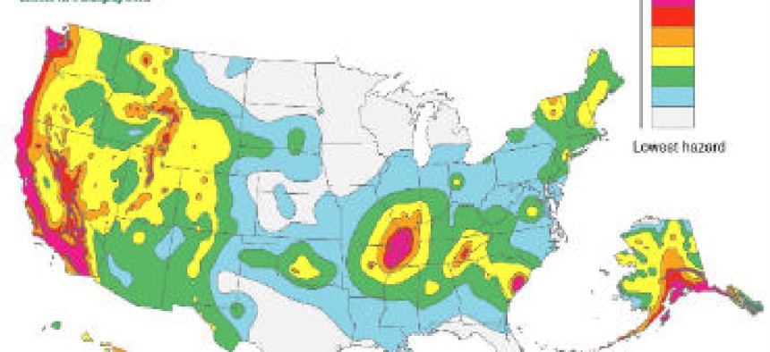
The maps show that 42 states are at risk, with 16 facing high risk. While those 16 have historically experienced earthquakes with a magnitude six or greater, the eastern United States has the potential for larger and more damaging earthquakes than considered in previous assessments, the agency said.
The 2011 5.8 magnitude earthquake in central Virginia that shook Washington, D.C., and forced the closure of the Washington Monument was felt as far away as New York City. It was among the strongest along the east coast in 100 years, USGS said, and reminded residents that larger seismic events are possible in the region.
The update led the National Earthquake Hazards Reduction Program to include states and specific geographical areas in the new maps that haven't been considered risky, including Utah and Oklahoma.
Not surprisingly, USGS said the hazard is especially high along the west coast, in the intermountain west, and in several active regions of the central U.S., including near New Madrid, Mo., the location of an historically dangerous fault line. The 16 states at highest risk are Alaska, Arkansas, California, Hawaii, Idaho, Illinois, Kentucky, Missouri, Montana, Nevada, Oregon, South Carolina, Tennessee, Utah, Washington and Wyoming.
"With an understanding of potential ground shaking levels, various risk analyses can be calculated by considering factors like population levels, building exposure and building construction practices," USGS said.