A closer look at 'Map of the World'


As NGA's geodata platform matures, hopes for payoffs rise.
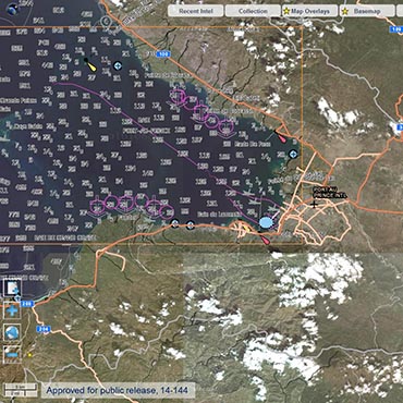
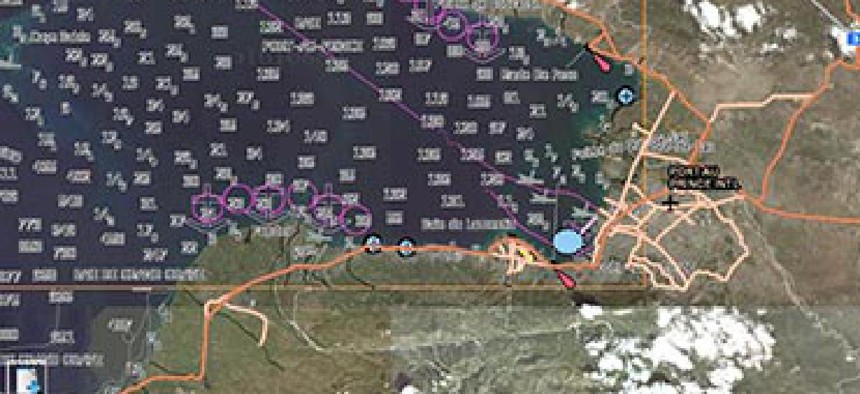
The National Geospatial-Intelligence Agency's Map of the World provides an ever-expanding set of searchable databases using, among other sources, commercial and classified satellite data. (Photo: NGA)
The National Geospatial-Intelligence Agency might be the most important U.S. intelligence agency your mother's never heard of. It has little public name recognition compared to the CIA or the National Security Agency and yet, with a sprawling Springfield, Va., campus and an ample budget, NGA is remaking how the intelligence community processes data gathered in the field.
Underpinning the IC’s shift to more integrated geospatial intelligence is NGA’s Map of the World, a set of searchable databases available to agencies and contractors that NGA is gradually expanding. The “map” taps into a trove of commercial and classified satellite data, among many other sources. When fully implemented, it will give analysts an ever-updated view of intelligence gathered around the world.
FCW recently visited NGA headquarters for a demonstration of the Map of the World and an update on the project in which Director of National Intelligence James Clapper has taken a strong personal interest.
The man in charge of the map is John Goolgasian, a two-decade veteran of NGA who said the project is taking flight in part because of the widespread commercialization of geographic information systems. Some 85 percent of transportation-related data for the map comes from the commercial sector rather than government, he estimated.
“What we’re doing is giving the [intelligence community] a consistent content set to work from spatially that has not really existed before,” Goolgasian said. “Because up until then, yes we were providing information, but there was no one governing what information was going to be used in any individual application.”
NGA was in the map business well before the Internet, which posed both a challenge and an opportunity to make its reams of maps easily accessible to intelligence analysts.
“For 34 years we had been creating standard products for our customer base: air information products for Air Force and other aviators, navigational charts for maritime … [and] topographic maps,” Goolgasian said.
“And then when we started moving from the paper world to the digital world, we really didn’t change the business process,” he added. “And what we ended up with was a number of different databases based on the products that we created.”
The multiple databases bred “conflicting and duplicative data over the same areas,” he explained. Eight different databases contributed information on an airfield in Africa, for example. The data was accurate but didn’t present a unified, discernable picture to intelligence analysts.
The shift from paper to digital did not have high-tech beginnings: Goolgasian said he and a colleague drew up the Map of the World on a piece of scrap paper.
NGA unveiled the first iteration of Map of the World in December 2013. Nine data layers were available when FCW spoke with NGA Director Letitia Long in April, with a topographic layer added shortly after, and two more to come in August to round out the first operational version of the map.
A demo showed maritime data with changing depths off the coast of Haiti. The maritime data had markings indicating a shipwreck to warn vessels of danger. An analyst more interested in aeronautical data can draw that up.
Goolgasian explained how adding variables to a search can increase the value of intelligence. “Show me North Korea, show me North Korean missiles, show me North Korean missiles active in the last three days, click on it and I see all of the intelligence information that is known on that missile facility in the last three days,” he said.
Though the NGA developed the map, it needn’t reside within the agency. It is meant to be portable so that once accessed by another agency or intelligence firm, it does not have to be downloaded again. “So I don’t have to come to NGA’s website to get this information. I can just touch a service end point and embed the information at any one of the agencies,” Goolgasian explained.
The data can be published in multiple formats so users can view it with Google Earth or another interface. NGA is trying to enable this by using open standards when possible.
The bigger picture offered by the map is one of operational intelligence for some of the biggest U.S. foreign policy decisions.
“How do you make that difficult decision about a manhunt or about what is happening in Iraq today, or are the Russians going to come over the border into the Ukraine?” Goolgasian asked. “You need that foundation to immerse yourself with all of the intelligence information. … And we believe we’re building a foundation to do that that the entire community can learn from.”